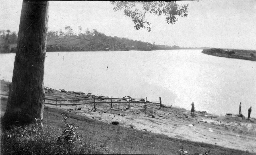
The rare photograph above, taken by Newcastle girl Doris Schuck in about 1919, shows Shelley Beach, on the Hunter River at Mayfield. Shelley Beach and its adjoining park were treasured by Newcastle people until overwhelming pressure from the BHP steelworks led to the public reserve being handed over to the corporate giant for reclamation and industrial expansion. These days the former park and beach are buried under tonnes of industrial fill in the approaches to the Tourle Street bridge, leading to what is now Kooragang Island.
Shelley Beach fronted “Platt’s Channel”, once a broad arm of the river to the south of Spit Island. Mrs Ellen Lane, whose father worked for the Australian Agricultural Company that once owned the land above Shelley Beach, grew up on the land now known as Steel River, when it was essentially rural. The property was dominated by the lovely mansion known as Argyle House, and the river beach was a favourite resort of people for miles around who flocked there to walk, court, fish and go boating. Mrs Lane recorded that her idyllic childhood was interrupted by the AA Co’s rezoning and sale of much of the land for new residential subdivisions. Argyle House was sold to the Catholic Church, which turned it into the Murray Dwyer orphanage.

BHP began agitating as early as 1939 to take over the riverside land for possible future expansion. In that year the NSW government appointed Newcastle City Council as trustee for Shelley Beach Park, signalling the beginning of the end for the popular public facility. Despite fierce resistance from residents and members of the Labor Party, the all-powerful company steadily closed in on its goal to erase the beach, the park and Platt’s Channel. Opponents argued that BHP had already taken over almost the entire river frontage from the harbour up, and that there were now hardly any public access points to the river.
In 1945 the company offered the state government land at Shortland as a swap for Platt’s Channel. At that time the steelworks was generating 30,000 tonnes of waste a year, and the channel was seen as an ideal dump. As a sweetener to Newcastle City Council, the company also offered a portion of land near Bull Street, Mayfield, to replace Shelley Beach Park.
In 2023 many people find it hard to believe that such a place as Shelley Beach, Spit Island or Platt’s Channel ever existed, so thoroughly have all traces been erased. But they did exist, and their loss was just one more instalment in the heavy payment made for industrial development in Newcastle.

In the Great Depression a number of families lived in makeshift “boatsheds” built over the mudflats opposite Spit Island. Below the tideline these sheds – about 28 of them – were exempt from council rates and their owners paid peppercorn rents to the Lands Department. Fishing was a constant pastime for many people, and before the river became too polluted it yielded huge quantities of food.
One former boatshed resident, the late Ted Bartlett, told me some years ago of his life on the river, and he recounted an episode during the filling of Platt’s Channel. At the time, the channel had been almost closed off, with just enough tidal exchange to feed the fish and other creatures trapped inside. “The prawns grew huge, and I filled tin after tin with them and sold them at work, and the mullet were massive too,” he said. But the secret got out and a trawlerman cleaned up the trapped harvest. Not long after, the island and the channel vanished forever.
All across the estuary, the same thing was happening as old islands with old names disappeared from maps and memory. Walsh Island, which was mainly mud flats and often mostly under water. Dempsey Island. Spectacle Island. Goat Island. Upper and Lower Moscheto Islands. And glorious Ash Island, a densely-forested wonderland that had left early European settlers in breathless awe of its sylvan beauty.
BHP and its satellites spread along the river’s edge, using the Hunter as a drain and using their waste products as fill to reclaim more land for their growth.
The government project to join the Hunter River islands and turn them into one big industrial estate – Kooragang – was a natural extension of the view that Newcastle’s only future lay in heavy industry.
THE ARTICLE ABOVE APPEARS IN OUR NEW BOOK, THEN AGAIN. CLICK HERE TO BUY THE BOOK.


Greg, love this article and so would our dearly departed Vera Deacon OAM. She was very passionate about Moscheto Island, Shelley Beach and the various Hunter River Islands. I recall she had City of Newcastle officers come out so she could step you where the Beach previous was. Up at Ash Island as a veteran tree-planter I named her “Matriach of the Islands”, which ultimately stuck, and in her later years the former KWRP volunteers (now Friends of the Schoolmaster’s House, Ash Island) even presented her with a gold key naming her as such, such was our love of her.
Secondly the article is well-received because after exiting the now Tourle Street Bridge, heading towards Stockton, where the road comes out of the bend if you look to the left you are looking at what was once my 2x Great Grandfather’s 40 acres of land, leased by private arrangement from R Fisher (Stockton Tweed Mill). Franz SCHUCK and his young family settled on the land in late 1865-early 1866 and the last SCHUCKs (his son Robert and his family) stayed until 1912 truly sick of the constant flooding. The family etched out an existence as market gardeners, rowing their produce down to the Newcastle Markets on the tide. Many of his children married Islander families and they often went back, well into the late 1920s, for family reunions. Franz’s sons grew up to be scullers, boatmen, fishermen, watermen in Newcastle Harbour, market gardeners, apiarists and vinedressers (Franz having brought cuttings of vines out from Germany when he arrived aboard the Catteaux Wattle in 1855 and serving out his bonding at Edwin Hickey’s “Osterley” prior to settling on Ash Island).
Franz and his young family would have interacted with the indigenous who often frequented the land in the 100m Aboriginal Reservation, which I see identified on the map contained in your article.
Doris Schuck is a granddaughter to Franz and we have spoken many times about her early childhood years.
I have seen an aerial photo of the old Argyle House before its demolition in a photograph album belonging to NSW Public Works in their Newcastle Office, showing its location and surrounds. The album is kept in a display case in the Bull Street Government Offices.
I would love to see that album!
Got a copy of the land transfer papers.
Excellent!